Before we start, did you have followed the setup steps described at here
Let’s explore data
- let’s process some services available
# this object contains some of the services available in GeoSampa

saopaulo.data.equipamentosList

allEquipamentos <- saopaulo.data.downloadBatch(saopaulo.data.equipamentosList )
#this creates a list of lists
collectionOfEquipamentos <-  saopaulo.data.processShapeListsAsList(allEquipamentos,"sirgas|SIRGAS")

# test your data
plot(collectionOfEquipamentos[[4]])
- Detect what build it is an equipament
#Edification
Edificacao = geofracker.downloadAndUnzipShp(saopaulo.data.edificacaoList[79])
#http://geosampa.prefeitura.sp.gov.br/PaginasPublicas/downloadArquivoOL.aspx?orig=DownloadCamadas&arq=06_Habita%E7%E3o%20e%20Edifica%E7%E3o%5C%5CEdifica%E7%E3o%5C%5CShapefile%5C%5CSHP_edificacao_AGUA_RASA&arqTipo=Shapefile

Edificacao1 <- readOGR(dsn=Edificacao$dir[1], layer=Edificacao$shapeclass[1])
plot(Edificacao1)
datasetIdx <- 25
#fix projection
proj4string(collectionOfEquipamentos[[datasetIdx]]) <- Edificacao1@proj4string


ct = rgeos::gContains( Edificacao1,collectionOfEquipamentos[[datasetIdx]],byid=TRUE, returnDense=TRUE )
#Returns a matrix of where colmns are Edificacao1
#Rows are collectionOfEquipamentos[[datasetIdx]]
ncol(ct) == length(Edificacao1)
length(ct[,1]) == length(collectionOfEquipamentos[[datasetIdx]])

Edificacao1@data$Area <- apply(ct, 2,any)
Edificacao1KnownServiceArea <- subset(Edificacao1, Edificacao1@data$Area == TRUE)


subset(Edificacao1, Edificacao1@data$Area == TRUE)

plot(Edificacao1)
#plot(Edificacao1[colsub,],add=T,col='green')
plot(collectionOfEquipamentos[[datasetIdx]],add=T,pch=16, col='red')
plot(Edificacao1KnownServiceArea,add=T,col='green')
Creating a function to mark special buildings:
geofracker.markServiceBuildings <- function(edifications, equipamentosCollection) {
df <- data.frame(matrix(ncol = 0, nrow = length(Edificacao1)))
index <- 1
i <- 0
for (equipament in collectionOfEquipamentos){
print(paste(length(shapeSource), "-",index))
#fix projection
proj4string(equipament) <- edifications@proj4string
ct = rgeos::gContains( edifications,equipament,byid=TRUE, returnDense=TRUE )
resultAppend <- apply(ct, 2,any)
df[,index] <- resultAppend
index <- index + 1
}
resultFinal <- apply(df,1,any)
return(resultFinal)
}
result <- geofracker.markServiceBuildings(Edificacao1,collectionOfEquipamentos)
Edificacao1@data$SpecialArea <- result
Edificacao1KnownServiceArea <- subset(Edificacao1, Edificacao1@data$SpecialArea == TRUE)
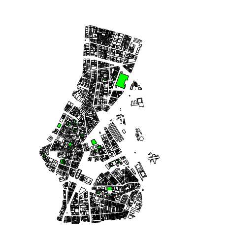
plot(Edificacao1)
plot(Edificacao1KnownServiceArea,add=T,col='green')
References:
http://www.ats.ucla.edu/stat/r/library/advanced_function_r.htm
http://www.cookbook-r.com/Manipulating_data/Adding_and_removing_columns_from_a_data_frame/
https://cran.r-project.org/web/packages/rgeos/rgeos.pdf
https://www.r-bloggers.com/rgeos-update/
https://www.nceas.ucsb.edu/scicomp/usecases/point-in-polygon
http://stackoverflow.com/questions/19002744/spover-for-point-in-polygon-analysis-in-r
comments powered by Disqus